𝐂𝐇𝐑𝐎𝐍𝐈𝐂𝐋𝐄𝐒 | 𝐓𝐀𝐔 𝐬𝐭𝐫𝐞𝐧𝐠𝐭𝐡𝐞𝐧𝐬 𝐬𝐨𝐢𝐥 𝐦𝐚𝐩𝐩𝐢𝐧𝐠 𝐜𝐚𝐩𝐚𝐜𝐢𝐭𝐲 𝐭𝐡𝐫𝐨𝐮𝐠𝐡 𝐁𝐒𝐖𝐌 𝐰𝐨𝐫𝐤𝐬𝐡𝐨𝐩
Tarlac Agricultural University (TAU) strengthened its capacity in soil fertility assessment and mapping as faculty members and students participated in the three-day “Capacity Building for the Soil Fertility Assessment and Mapping of Agricultural Areas in the Philippines” held from 15-17 September.
The workshop was conducted in collaboration with the Department of Agriculture - Bureau of Soils and Water Management (DA-BSWM) and the Department of Agriculture - Regional Soils Laboratory III. It provided participants with technical knowledge on soil fertility assessment, soil sample collection, and GIS-based soil fertility mapping.
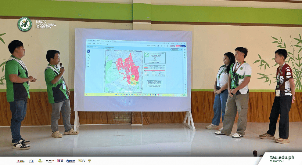
Throughout the three-day activity, participants engaged in lectures, technical training-workshops, and hands-on exercises focused on GIS-based soil fertility mapping. They learned how to process data, create maps, and interpret generated outputs, providing them with practical experience beyond classroom discussions.
For student participant Mr. Mark Candelario, a Bachelor of Science in Agriculture (BSA) major in Soil Science, the workshop offered a firsthand understanding of the complexities of actual soil mapping. He shared that the experience showed him that “soil fertility mapping involves collecting accurate field data, observing soil conditions, and interpreting differences in nutrients across an area.” He also added that these practices were difficult to fully grasp through classroom discussions alone.
Mr. Candelario also described the GIS mapping activities as challenging but valuable. One of the difficulties he encountered was the lack of a laptop for the mapping exercises. With the assistance of a professor who shared a laptop, however, he was able to participate and complete the activities. He noted that learning to create soil fertility maps through GIS could also benefit students conducting research and thesis work, particularly in locating areas and determining their extent.
The experience also changed his perception of soil mapping. “It is more than simply creating a map,” Mr. Candelario said, emphasizing the importance of accurate data collection and understanding soil conditions. He further recognized that soil mapping could help future agriculturists make better decisions regarding fertilizer application and soil management.
The workshop concluded with a technical presentation and feedback session on generated map outputs, followed by a post-test and awarding of certificates of completion. The activity equipped TAU faculty and students with practical skills in soil fertility mapping while reinforcing the importance of hands-on learning in preparing future agriculturists.
#SmartTAU #GreenandGlobal #SoilMapping #DA-BSWM #CollegeofAgricultureandForestry #TAUcommunity #SDG4 #SDG11 #SDG15 #SDG17
Text | Angelica A. Fe [College of Agriculture and Forestry]
Photos | Angelica A. Fe and Eugene Boongaling [BSWM]
Graphics | Carol Jane B. Caragay [Information Unit]